Error message
- Deprecated function: array_key_exists(): Using array_key_exists() on objects is deprecated. Use isset() or property_exists() instead in Drupal\Core\Controller\ControllerResolver->doGetArguments() (line 139 of core/lib/Drupal/Core/Controller/ControllerResolver.php).
- Deprecated function: array_key_exists(): Using array_key_exists() on objects is deprecated. Use isset() or property_exists() instead in Drupal\Core\Controller\ControllerResolver->doGetArguments() (line 139 of core/lib/Drupal/Core/Controller/ControllerResolver.php).
- Deprecated function: array_key_exists(): Using array_key_exists() on objects is deprecated. Use isset() or property_exists() instead in Twig_Template->getAttribute() (line 582 of vendor/twig/twig/lib/Twig/Template.php).
- Deprecated function: array_key_exists(): Using array_key_exists() on objects is deprecated. Use isset() or property_exists() instead in Twig_Template->getAttribute() (line 582 of vendor/twig/twig/lib/Twig/Template.php).
- Deprecated function: array_key_exists(): Using array_key_exists() on objects is deprecated. Use isset() or property_exists() instead in Twig_Template->getAttribute() (line 582 of vendor/twig/twig/lib/Twig/Template.php).
- Deprecated function: array_key_exists(): Using array_key_exists() on objects is deprecated. Use isset() or property_exists() instead in Twig_Template->getAttribute() (line 582 of vendor/twig/twig/lib/Twig/Template.php).
- Deprecated function: array_key_exists(): Using array_key_exists() on objects is deprecated. Use isset() or property_exists() instead in Twig_Template->getAttribute() (line 582 of vendor/twig/twig/lib/Twig/Template.php).
- Deprecated function: array_key_exists(): Using array_key_exists() on objects is deprecated. Use isset() or property_exists() instead in Twig_Template->getAttribute() (line 582 of vendor/twig/twig/lib/Twig/Template.php).
- Deprecated function: array_key_exists(): Using array_key_exists() on objects is deprecated. Use isset() or property_exists() instead in Twig_Template->getAttribute() (line 582 of vendor/twig/twig/lib/Twig/Template.php).
- Deprecated function: array_key_exists(): Using array_key_exists() on objects is deprecated. Use isset() or property_exists() instead in Twig_Template->getAttribute() (line 582 of vendor/twig/twig/lib/Twig/Template.php).
- Deprecated function: array_key_exists(): Using array_key_exists() on objects is deprecated. Use isset() or property_exists() instead in Twig_Template->getAttribute() (line 582 of vendor/twig/twig/lib/Twig/Template.php).
- Deprecated function: array_key_exists(): Using array_key_exists() on objects is deprecated. Use isset() or property_exists() instead in Twig_Template->getAttribute() (line 582 of vendor/twig/twig/lib/Twig/Template.php).
- Deprecated function: array_key_exists(): Using array_key_exists() on objects is deprecated. Use isset() or property_exists() instead in Twig_Template->getAttribute() (line 582 of vendor/twig/twig/lib/Twig/Template.php).
- Deprecated function: array_key_exists(): Using array_key_exists() on objects is deprecated. Use isset() or property_exists() instead in Twig_Template->getAttribute() (line 582 of vendor/twig/twig/lib/Twig/Template.php).
- Deprecated function: array_key_exists(): Using array_key_exists() on objects is deprecated. Use isset() or property_exists() instead in Twig_Template->getAttribute() (line 582 of vendor/twig/twig/lib/Twig/Template.php).
- Deprecated function: array_key_exists(): Using array_key_exists() on objects is deprecated. Use isset() or property_exists() instead in Twig_Template->getAttribute() (line 582 of vendor/twig/twig/lib/Twig/Template.php).
- Deprecated function: array_key_exists(): Using array_key_exists() on objects is deprecated. Use isset() or property_exists() instead in Twig_Template->getAttribute() (line 582 of vendor/twig/twig/lib/Twig/Template.php).
- Deprecated function: array_key_exists(): Using array_key_exists() on objects is deprecated. Use isset() or property_exists() instead in Twig_Template->getAttribute() (line 582 of vendor/twig/twig/lib/Twig/Template.php).
- Deprecated function: array_key_exists(): Using array_key_exists() on objects is deprecated. Use isset() or property_exists() instead in Twig_Template->getAttribute() (line 582 of vendor/twig/twig/lib/Twig/Template.php).
- Deprecated function: array_key_exists(): Using array_key_exists() on objects is deprecated. Use isset() or property_exists() instead in Twig_Template->getAttribute() (line 582 of vendor/twig/twig/lib/Twig/Template.php).
- Deprecated function: array_key_exists(): Using array_key_exists() on objects is deprecated. Use isset() or property_exists() instead in Twig_Template->getAttribute() (line 582 of vendor/twig/twig/lib/Twig/Template.php).
- Deprecated function: array_key_exists(): Using array_key_exists() on objects is deprecated. Use isset() or property_exists() instead in Twig_Template->getAttribute() (line 582 of vendor/twig/twig/lib/Twig/Template.php).
- Deprecated function: array_key_exists(): Using array_key_exists() on objects is deprecated. Use isset() or property_exists() instead in Twig_Template->getAttribute() (line 582 of vendor/twig/twig/lib/Twig/Template.php).
- Deprecated function: array_key_exists(): Using array_key_exists() on objects is deprecated. Use isset() or property_exists() instead in Twig_Template->getAttribute() (line 582 of vendor/twig/twig/lib/Twig/Template.php).
- Deprecated function: array_key_exists(): Using array_key_exists() on objects is deprecated. Use isset() or property_exists() instead in Twig_Template->getAttribute() (line 582 of vendor/twig/twig/lib/Twig/Template.php).
- Deprecated function: array_key_exists(): Using array_key_exists() on objects is deprecated. Use isset() or property_exists() instead in Twig_Template->getAttribute() (line 582 of vendor/twig/twig/lib/Twig/Template.php).
- Deprecated function: array_key_exists(): Using array_key_exists() on objects is deprecated. Use isset() or property_exists() instead in Twig_Template->getAttribute() (line 582 of vendor/twig/twig/lib/Twig/Template.php).
- Deprecated function: array_key_exists(): Using array_key_exists() on objects is deprecated. Use isset() or property_exists() instead in Twig_Template->getAttribute() (line 582 of vendor/twig/twig/lib/Twig/Template.php).
- Deprecated function: array_key_exists(): Using array_key_exists() on objects is deprecated. Use isset() or property_exists() instead in Twig_Template->getAttribute() (line 582 of vendor/twig/twig/lib/Twig/Template.php).
- Deprecated function: array_key_exists(): Using array_key_exists() on objects is deprecated. Use isset() or property_exists() instead in Twig_Template->getAttribute() (line 582 of vendor/twig/twig/lib/Twig/Template.php).
- Deprecated function: array_key_exists(): Using array_key_exists() on objects is deprecated. Use isset() or property_exists() instead in Twig_Template->getAttribute() (line 582 of vendor/twig/twig/lib/Twig/Template.php).
- Deprecated function: array_key_exists(): Using array_key_exists() on objects is deprecated. Use isset() or property_exists() instead in Twig_Template->getAttribute() (line 582 of vendor/twig/twig/lib/Twig/Template.php).
- Deprecated function: array_key_exists(): Using array_key_exists() on objects is deprecated. Use isset() or property_exists() instead in Twig_Template->getAttribute() (line 582 of vendor/twig/twig/lib/Twig/Template.php).
- Deprecated function: array_key_exists(): Using array_key_exists() on objects is deprecated. Use isset() or property_exists() instead in Twig_Template->getAttribute() (line 582 of vendor/twig/twig/lib/Twig/Template.php).
- Deprecated function: array_key_exists(): Using array_key_exists() on objects is deprecated. Use isset() or property_exists() instead in Twig_Template->getAttribute() (line 582 of vendor/twig/twig/lib/Twig/Template.php).
Building Capacities for conservation Planning using open source tools
Summary
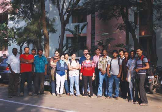
The project objectives were to build the capacities of conservation groups in the use of GIS and remote sensing in conservation planning. Particular focus was on those those agencies active in the CEPF programme in the Western Ghats. Application of spatial data for conservation planning requires both its availability as well as capacities to utilise it. The investments being made by CEPF in the Western Ghats portal will partly address the first part of this problem. The project intended to address the lack of capacities in conservation groups by conducting a minimum of four five day workshops on open source GIS, remote sensing and spatial statistics. Twenty persons were expected to be trained in each of the workshops.
Objectives
Over eighty researchers active in the field of conservation and ecology in the Western Ghats have been trained during this year in the use of spatially explicit tools. The workshops themselves were hosted by five different institutions. The reviews of the participants indicated that the training addressed an important gap in the capacities of these researchers to use spatially explicit data from a variety of sources in conservation related research. The project has also helped bring together an initial set of syllabi for teaching spatial analysis to ecologists based on discussions with experts in the field. This may have long term impacts on the quality of research outputs from institutions involved in these fields.
FERAL - once wild, runs wild again.